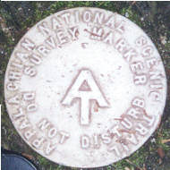
- 1 1/4 inch diameter
- Cast in fine pewter
- Strong magnet embedded in back
- Mounted on story card
Place Name: Appalachian Trail
Distance: 2,190 miles
Total Elevation Gain/Loss: ~464,500 feet
Location: Georgia to Maine, USA
The Appalachian Trail was conceived in 1931 by Benton MacKaye, forester, planner and conservationist. The trail was completed in 1937 and later came under the management of the National Park Service, the US Forest Service and the Appalachian Trail Conservancy. The trail is maintained by trail clubs and multiple partnerships. The trail passes through 14 Eastern states. This marker bears the 2-letter state designations GA-ME to represent the trailheads located at Springer Mountain, Georgia and Mount Katahdin, Maine.


